[{"id":"3789","link":"https:\/\/geosearth.com\/portada\/iso\/","name":"iso","thumbnail":{"url":"https:\/\/geosearth.com\/wp-content\/uploads\/2025\/10\/certificaciones-iso-geosearth-2025.jpg","alt":""},"title":"Nos comprometemos con los m\u00e1s altos est\u00e1ndares internacionales de calidad, sostenibilidad y \u00e9tica empresarial","author":{"name":"John Maylle","link":"https:\/\/geosearth.com\/author\/john\/"},"date":"Oct 5, 2025","dateGMT":"2025-10-05 22:28:56","modifiedDate":"2025-10-05 17:44:49","modifiedDateGMT":"2025-10-05 22:44:49","commentCount":"0","commentStatus":"open","categories":{"coma":"<a href=\"https:\/\/geosearth.com\/category\/portada\/\" rel=\"category tag\">portada<\/a>","space":"<a href=\"https:\/\/geosearth.com\/category\/portada\/\" rel=\"category tag\">portada<\/a>"},"taxonomies":{"post_tag":""},"readTime":{"min":0,"sec":0},"status":"publish","content":""},{"id":"3730","link":"https:\/\/geosearth.com\/productos\/escaner-lidar-fjd-trion-s2-series\/","name":"escaner-lidar-fjd-trion-s2-series","thumbnail":{"url":"https:\/\/geosearth.com\/wp-content\/uploads\/2025\/08\/fjd-trion-s2.jpg","alt":""},"title":"ESC\u00c1NER LIDAR FJD TRION S2 SERIES","author":{"name":"John Maylle","link":"https:\/\/geosearth.com\/author\/john\/"},"date":"Ago 26, 2025","dateGMT":"2025-08-27 03:31:35","modifiedDate":"2025-08-26 22:36:58","modifiedDateGMT":"2025-08-27 03:36:58","commentCount":"0","commentStatus":"closed","categories":{"coma":"<a href=\"https:\/\/geosearth.com\/category\/productos\/\" rel=\"category tag\">productos<\/a>","space":"<a href=\"https:\/\/geosearth.com\/category\/productos\/\" rel=\"category tag\">productos<\/a>"},"taxonomies":{"post_tag":""},"readTime":{"min":4,"sec":36},"status":"publish","content":"Precisi\u00f3n de 1,2 cm Colorizaci\u00f3n en tiempo real Algoritmos multi-SLAM Nube de puntos georreferenciada Adaptaci\u00f3n a m\u00faltiples escenarios Escaneo en interiores y exteriores MENOR TAMA\u00d1O,"},{"id":"3688","link":"https:\/\/geosearth.com\/productos\/fjd-trion-v10a-sistema-rtk-con-replanteo-ar\/","name":"fjd-trion-v10a-sistema-rtk-con-replanteo-ar","thumbnail":{"url":"https:\/\/geosearth.com\/wp-content\/uploads\/2025\/08\/FJD-Trion-V10a.jpg","alt":""},"title":"FJD TRION V10a: Sistema RTK con replanteo AR","author":{"name":"John Maylle","link":"https:\/\/geosearth.com\/author\/john\/"},"date":"Ago 26, 2025","dateGMT":"2025-08-26 20:34:19","modifiedDate":"2025-08-26 22:37:46","modifiedDateGMT":"2025-08-27 03:37:46","commentCount":"0","commentStatus":"closed","categories":{"coma":"<a href=\"https:\/\/geosearth.com\/category\/productos\/\" rel=\"category tag\">productos<\/a>","space":"<a href=\"https:\/\/geosearth.com\/category\/productos\/\" rel=\"category tag\">productos<\/a>"},"taxonomies":{"post_tag":""},"readTime":{"min":2,"sec":49},"status":"publish","content":"C\u00e1maras duales de 5 MP, Campo de visi\u00f3n de 83\u00b0 13 cm de di\u00e1metro y 800 g; 18 % m\u00e1s peque\u00f1o, 15 % m\u00e1s ligero"},{"id":"3580","link":"https:\/\/geosearth.com\/productos\/escaner-laser-x120go-slam-stonex\/","name":"escaner-laser-x120go-slam-stonex","thumbnail":{"url":false,"alt":false},"title":"Esc\u00e1ner l\u00e1ser X120GO SLAM Stonex","author":{"name":"John Maylle","link":"https:\/\/geosearth.com\/author\/john\/"},"date":"Dic 17, 2024","dateGMT":"2024-12-17 13:23:13","modifiedDate":"2025-01-18 11:18:22","modifiedDateGMT":"2025-01-18 16:18:22","commentCount":"0","commentStatus":"closed","categories":{"coma":"<a href=\"https:\/\/geosearth.com\/category\/productos\/\" rel=\"category tag\">productos<\/a>","space":"<a href=\"https:\/\/geosearth.com\/category\/productos\/\" rel=\"category tag\">productos<\/a>"},"taxonomies":{"post_tag":""},"readTime":{"min":1,"sec":43},"status":"publish","content":"Esc\u00e1ner l\u00e1ser X120GO SLAM Stonex Preciso y vers\u00e1til con cabezal giratorio de 360\u00b0 genera una cobertura de nube de puntos de 360\u00b0x270\u00b0 Caracter\u00edsticas BROCHURE &"},{"id":"3559","link":"https:\/\/geosearth.com\/productos\/receptor-gnss-s999\/","name":"receptor-gnss-s999","thumbnail":{"url":"https:\/\/geosearth.com\/wp-content\/uploads\/2024\/12\/S999-img3.jpg","alt":""},"title":"Receptor GNSS S999","author":{"name":"John Maylle","link":"https:\/\/geosearth.com\/author\/john\/"},"date":"Dic 16, 2024","dateGMT":"2024-12-16 18:36:24","modifiedDate":"2025-01-18 11:10:57","modifiedDateGMT":"2025-01-18 16:10:57","commentCount":"0","commentStatus":"closed","categories":{"coma":"<a href=\"https:\/\/geosearth.com\/category\/productos\/\" rel=\"category tag\">productos<\/a>","space":"<a href=\"https:\/\/geosearth.com\/category\/productos\/\" rel=\"category tag\">productos<\/a>"},"taxonomies":{"post_tag":"<a href='https:\/\/geosearth.com\/tag\/receptor-gnss\/' rel='post_tag'>Receptor GNSS<\/a>"},"readTime":{"min":2,"sec":15},"status":"publish","content":"Receptor GNSS S999 Doble Camara Caracter\u00edsticas BROCHURE & DATASHEET GALERIA VIDEO PREGUNTAS FRECUENTES Caracter\u00edsticas El S999 est\u00e1 equipado con 1408 canales multiconstelaci\u00f3n, garantiza un posicionamiento"},{"id":"3502","link":"https:\/\/geosearth.com\/productos\/receptor-stonex-gnss-s900\/","name":"receptor-stonex-gnss-s900","thumbnail":{"url":false,"alt":false},"title":"Receptor Stonex GNSS S900+","author":{"name":"John Maylle","link":"https:\/\/geosearth.com\/author\/john\/"},"date":"Dic 15, 2024","dateGMT":"2024-12-15 16:56:33","modifiedDate":"2025-01-18 11:18:06","modifiedDateGMT":"2025-01-18 16:18:06","commentCount":"0","commentStatus":"closed","categories":{"coma":"<a href=\"https:\/\/geosearth.com\/category\/productos\/\" rel=\"category tag\">productos<\/a>","space":"<a href=\"https:\/\/geosearth.com\/category\/productos\/\" rel=\"category tag\">productos<\/a>"},"taxonomies":{"post_tag":"<a href='https:\/\/geosearth.com\/tag\/receptor-gnss\/' rel='post_tag'>Receptor GNSS<\/a>"},"readTime":{"min":2,"sec":34},"status":"publish","content":"Receptor Stonex GNSS S900+ GNSS S900+ Potente Rendimiento de Precisi\u00f3n Stonex S900+ esta equipado con una placa GNSS de alto rendimiento con 1408 canales y"},{"id":"3468","link":"https:\/\/geosearth.com\/productos\/tablet-gnss-t10\/","name":"tablet-gnss-t10","thumbnail":{"url":false,"alt":false},"title":"TABLET GNSS T10","author":{"name":"John Maylle","link":"https:\/\/geosearth.com\/author\/john\/"},"date":"Oct 20, 2024","dateGMT":"2024-10-20 20:13:24","modifiedDate":"2025-01-18 11:38:59","modifiedDateGMT":"2025-01-18 16:38:59","commentCount":"0","commentStatus":"closed","categories":{"coma":"<a href=\"https:\/\/geosearth.com\/category\/productos\/\" rel=\"category tag\">productos<\/a>","space":"<a href=\"https:\/\/geosearth.com\/category\/productos\/\" rel=\"category tag\">productos<\/a>"},"taxonomies":{"post_tag":""},"readTime":{"min":1,"sec":37},"status":"publish","content":"PANTALLA HD DE 10,1\" La gran pantalla t\u00e1ctil HD de 10,1\" legible bajo la luz del sol del T10 ofrece una experiencia visual y operativa"},{"id":"3455","link":"https:\/\/geosearth.com\/productos\/tablet-gnss-t8-pro\/","name":"tablet-gnss-t8-pro","thumbnail":{"url":false,"alt":false},"title":"Tablet GNSS T8 PRO","author":{"name":"John Maylle","link":"https:\/\/geosearth.com\/author\/john\/"},"date":"Oct 20, 2024","dateGMT":"2024-10-20 18:05:11","modifiedDate":"2025-01-18 11:38:49","modifiedDateGMT":"2025-01-18 16:38:49","commentCount":"0","commentStatus":"closed","categories":{"coma":"<a href=\"https:\/\/geosearth.com\/category\/productos\/\" rel=\"category tag\">productos<\/a>","space":"<a href=\"https:\/\/geosearth.com\/category\/productos\/\" rel=\"category tag\">productos<\/a>"},"taxonomies":{"post_tag":""},"readTime":{"min":1,"sec":46},"status":"publish","content":"PRECISI\u00d3N EN CENT\u00cdMETROS Integrado con un m\u00f3dulo GNSS de alta precisi\u00f3n, el T8 Pro puede rastrear simult\u00e1neamente todas las constelaciones en ejecuci\u00f3n y planificadas, proporcionando"},{"id":"3444","link":"https:\/\/geosearth.com\/productos\/receptor-gnss-y1\/","name":"receptor-gnss-y1","thumbnail":{"url":false,"alt":false},"title":"RECEPTOR GNSS Y1","author":{"name":"John Maylle","link":"https:\/\/geosearth.com\/author\/john\/"},"date":"Oct 20, 2024","dateGMT":"2024-10-20 15:45:51","modifiedDate":"2025-01-18 11:38:40","modifiedDateGMT":"2025-01-18 16:38:40","commentCount":"0","commentStatus":"closed","categories":{"coma":"<a href=\"https:\/\/geosearth.com\/category\/productos\/\" rel=\"category tag\">productos<\/a>","space":"<a href=\"https:\/\/geosearth.com\/category\/productos\/\" rel=\"category tag\">productos<\/a>"},"taxonomies":{"post_tag":""},"readTime":{"min":3,"sec":20},"status":"publish","content":"CONSTELACI\u00d3N COMPLETA Con 1598 canales para el seguimiento completo de la constelaci\u00f3n, el Y1 puede ofrecer un posicionamiento confiable con precisi\u00f3n de nivel centim\u00e9trico. Gracias"},{"id":"3414","link":"https:\/\/geosearth.com\/productos\/receptor-gnss-x1-pro\/","name":"receptor-gnss-x1-pro","thumbnail":{"url":false,"alt":false},"title":"RECEPTOR GNSS X1 PRO","author":{"name":"John Maylle","link":"https:\/\/geosearth.com\/author\/john\/"},"date":"Oct 19, 2024","dateGMT":"2024-10-19 20:15:00","modifiedDate":"2025-01-18 11:38:31","modifiedDateGMT":"2025-01-18 16:38:31","commentCount":"0","commentStatus":"closed","categories":{"coma":"<a href=\"https:\/\/geosearth.com\/category\/productos\/\" rel=\"category tag\">productos<\/a>","space":"<a href=\"https:\/\/geosearth.com\/category\/productos\/\" rel=\"category tag\">productos<\/a>"},"taxonomies":{"post_tag":""},"readTime":{"min":4,"sec":34},"status":"publish","content":"Constelaci\u00f3n completa, fija en segundos Con seguimiento de se\u00f1al resistente de constelaci\u00f3n completa, antiinterferencias robusto y algoritmo RTK avanzado, X1 Pro solo tarda unos segundos"},{"id":"3381","link":"https:\/\/geosearth.com\/productos\/receptor-gnss-orion-one\/","name":"receptor-gnss-orion-one","thumbnail":{"url":false,"alt":false},"title":"RECEPTOR GNSS ORION ONE","author":{"name":"John Maylle","link":"https:\/\/geosearth.com\/author\/john\/"},"date":"Oct 19, 2024","dateGMT":"2024-10-19 18:11:25","modifiedDate":"2025-01-18 11:38:26","modifiedDateGMT":"2025-01-18 16:38:26","commentCount":"0","commentStatus":"closed","categories":{"coma":"<a href=\"https:\/\/geosearth.com\/category\/productos\/\" rel=\"category tag\">productos<\/a>","space":"<a href=\"https:\/\/geosearth.com\/category\/productos\/\" rel=\"category tag\">productos<\/a>"},"taxonomies":{"post_tag":""},"readTime":{"min":4,"sec":33},"status":"publish","content":"Peque\u00f1o en mano, poderoso en estudio Orion ONE est\u00e1 dise\u00f1ado con un dise\u00f1o compacto de \u03a6107 mm \u00d7 58,7 mm del tama\u00f1o de la palma"},{"id":"3335","link":"https:\/\/geosearth.com\/blog\/isl-mejora-del-rendimiento-de-los-mensajes-de-navegacion-gnss\/","name":"isl-mejora-del-rendimiento-de-los-mensajes-de-navegacion-gnss","thumbnail":{"url":"https:\/\/geosearth.com\/wp-content\/uploads\/2024\/06\/image.png","alt":""},"title":"ISL: Mejora del rendimiento de los mensajes de navegaci\u00f3n GNSS","author":{"name":"geos","link":"https:\/\/geosearth.com\/author\/geos\/"},"date":"Jun 2, 2024","dateGMT":"2024-06-02 23:19:25","modifiedDate":"2024-06-06 11:55:17","modifiedDateGMT":"2024-06-06 16:55:17","commentCount":"0","commentStatus":"closed","categories":{"coma":"<a href=\"https:\/\/geosearth.com\/category\/blog\/\" rel=\"category tag\">blog<\/a>","space":"<a href=\"https:\/\/geosearth.com\/category\/blog\/\" rel=\"category tag\">blog<\/a>"},"taxonomies":{"post_tag":""},"readTime":{"min":26,"sec":47},"status":"publish","content":"Sat\u00e9lite Galileo en \u00f3rbita. Imagen: ESA-P. Carril. Aprovechar los Inter-Satellite Links(ISL, enlaces entre sat\u00e9lites) de alta precisi\u00f3n para la comunicaci\u00f3n y el alcance entre sat\u00e9lites"}]
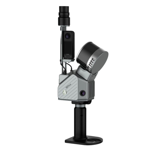
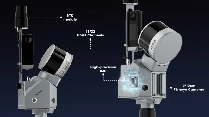
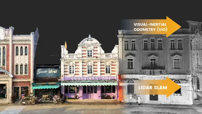
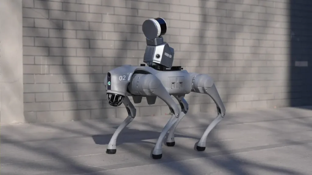
El escáner LIDAR FJD Trion S2 incorpora algoritmos avanzados VIO y SLAM para generar nubes de puntos fiables y de alta calidad. Compatible con más de 8000 sistemas de coordenadas, el S2 elimina la necesidad de largas conversiones manuales de coordenadas. Al integrarse con el software FJD Trion Scan and Model y utilizar accesorios prácticos como chaleco estabilizador, soporte para dron, soporte para coche y soporte para perro robot, el S2 optimiza la captura y el procesamiento de datos en proyectos de topografía en exteriores.
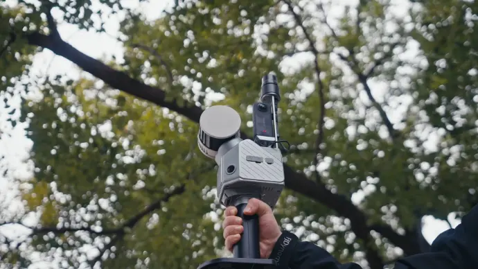
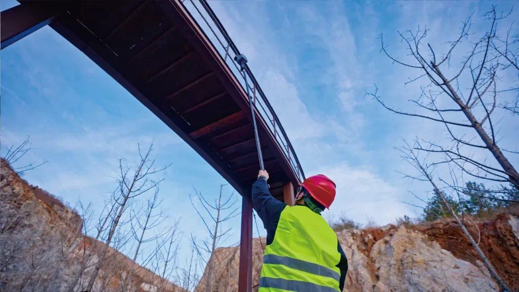
Capture nubes de puntos en todas direcciones, incluso en zonas de difícil acceso, con prácticos accesorios, como chaleco estabilizador, bastón extensible, dron, perro robot y maleta con ruedas. Puede escanear donde y cuando quiera.
Escanee con facilidad: capture, previsualice y perfeccione en tiempo real. La visualización instantánea de la nube de puntos coloreada del S2 le permite verificar la calidad y la cobertura del escaneo in situ, eliminando áreas omitidas y retrabajos antes de irse.