[{"id":"4012","price":"","sale":"","sale_percent":"","link":"https:\/\/geosearth.com\/portada\/receptor-gnss-laser-jupiter-rtk\/","name":"receptor-gnss-laser-jupiter-rtk","thumbnail":{"url":"https:\/\/geosearth.com\/wp-content\/uploads\/2026\/05\/Laser-Jupiter-RTK-GNSS.webp","alt":""},"title":"Receptor GNSS: L\u00e1ser J\u00fapiter RTK","author":{"name":"geos","link":"https:\/\/geosearth.com\/author\/geos\/"},"date":"May 26, 2026","dateGMT":"2026-05-26 20:45:56","modifiedDate":"2026-05-27 16:31:12","modifiedDateGMT":"2026-05-27 21:31:12","commentCount":"0","commentStatus":"closed","categories":{"coma":"<a href=\"https:\/\/geosearth.com\/category\/portada\/\" rel=\"category tag\">portada<\/a>, <a href=\"https:\/\/geosearth.com\/category\/productos\/\" rel=\"category tag\">productos<\/a>","space":"<a href=\"https:\/\/geosearth.com\/category\/portada\/\" rel=\"category tag\">portada<\/a> <a href=\"https:\/\/geosearth.com\/category\/productos\/\" rel=\"category tag\">productos<\/a>"},"taxonomies":{"post_tag":""},"acf_fields":[],"readTime":{"min":4,"sec":15},"status":"publish","content":"L\u00e1ser J\u00fapiter RTK Caracter\u00edsticas El Jupiter Laser RTK es un receptor GNSS de alta gama que integra tecnolog\u00edas avanzadas de GNSS, IMU, l\u00e1ser y c\u00e1maras"},{"id":"4002","price":"","sale":"","sale_percent":"","link":"https:\/\/geosearth.com\/portada\/sonda-acustica-portatil-hyd10\/","name":"sonda-acustica-portatil-hyd10","thumbnail":{"url":"https:\/\/geosearth.com\/wp-content\/uploads\/2026\/05\/ecosonda-portatil-hyd10.webp","alt":""},"title":"Sonda ac\u00fastica port\u00e1til HYD10","author":{"name":"geos","link":"https:\/\/geosearth.com\/author\/geos\/"},"date":"May 25, 2026","dateGMT":"2026-05-25 19:41:02","modifiedDate":"2026-05-27 15:44:19","modifiedDateGMT":"2026-05-27 20:44:19","commentCount":"0","commentStatus":"closed","categories":{"coma":"<a href=\"https:\/\/geosearth.com\/category\/portada\/\" rel=\"category tag\">portada<\/a>, <a href=\"https:\/\/geosearth.com\/category\/productos\/\" rel=\"category tag\">productos<\/a>","space":"<a href=\"https:\/\/geosearth.com\/category\/portada\/\" rel=\"category tag\">portada<\/a> <a href=\"https:\/\/geosearth.com\/category\/productos\/\" rel=\"category tag\">productos<\/a>"},"taxonomies":{"post_tag":""},"acf_fields":[],"readTime":{"min":1,"sec":40},"status":"publish","content":"Caracter\u00edsticas El HYD10 es una sonda port\u00e1til de nueva generaci\u00f3n desarrollada por ComNav. Con un dise\u00f1o compacto, permite la medici\u00f3n autom\u00e1tica de la profundidad. Gracias"},{"id":"3996","price":"","sale":"","sale_percent":"","link":"https:\/\/geosearth.com\/portada\/ecosonda-hyd300\/","name":"ecosonda-hyd300","thumbnail":{"url":"https:\/\/geosearth.com\/wp-content\/uploads\/2026\/05\/ECOSONDA-HYD300.webp","alt":""},"title":"Ecosonda HYD300","author":{"name":"geos","link":"https:\/\/geosearth.com\/author\/geos\/"},"date":"May 25, 2026","dateGMT":"2026-05-25 19:04:50","modifiedDate":"2026-05-25 14:07:12","modifiedDateGMT":"2026-05-25 19:07:12","commentCount":"0","commentStatus":"closed","categories":{"coma":"<a href=\"https:\/\/geosearth.com\/category\/portada\/\" rel=\"category tag\">portada<\/a>, <a href=\"https:\/\/geosearth.com\/category\/productos\/\" rel=\"category tag\">productos<\/a>","space":"<a href=\"https:\/\/geosearth.com\/category\/portada\/\" rel=\"category tag\">portada<\/a> <a href=\"https:\/\/geosearth.com\/category\/productos\/\" rel=\"category tag\">productos<\/a>"},"taxonomies":{"post_tag":""},"acf_fields":[],"readTime":{"min":1,"sec":16},"status":"publish","content":"HYD300: Ecosonda ac\u00fastica profesional para levantamientos hidrogr\u00e1ficos de alta precisi\u00f3n La HYD300 es una ecosonda ac\u00fastica dise\u00f1ada para trabajos hidrogr\u00e1ficos profesionales, ideal para medir profundidades"},{"id":"3926","price":"","sale":"","sale_percent":"","link":"https:\/\/geosearth.com\/productos\/escaner-laser-fjd-trion-p2\/","name":"escaner-laser-fjd-trion-p2","thumbnail":{"url":"https:\/\/geosearth.com\/wp-content\/uploads\/2026\/05\/escanerlidarp2.jpg","alt":""},"title":"Esc\u00e1ner L\u00e1ser FJD Trion P2","author":{"name":"geos","link":"https:\/\/geosearth.com\/author\/geos\/"},"date":"May 18, 2026","dateGMT":"2026-05-18 18:53:07","modifiedDate":"2026-05-26 22:46:12","modifiedDateGMT":"2026-05-27 03:46:12","commentCount":"0","commentStatus":"open","categories":{"coma":"<a href=\"https:\/\/geosearth.com\/category\/productos\/\" rel=\"category tag\">productos<\/a>","space":"<a href=\"https:\/\/geosearth.com\/category\/productos\/\" rel=\"category tag\">productos<\/a>"},"taxonomies":{"post_tag":""},"acf_fields":[],"readTime":{"min":4,"sec":27},"status":"publish","content":"M\u00e1s peque\u00f1o, m\u00e1s inteligente, escanea m\u00e1s. El FJD Trion P2 marca una nueva generaci\u00f3n en tecnolog\u00eda LiDAR port\u00e1til, dise\u00f1ado para ofrecer precisi\u00f3n centim\u00e9trica, procesamiento en"},{"id":"3875","price":"","sale":"","sale_percent":"","link":"https:\/\/geosearth.com\/portada\/iusv-8-vehiculo-de-superficie-autonomo-para-levantamientos-hidrograficos\/","name":"iusv-8-vehiculo-de-superficie-autonomo-para-levantamientos-hidrograficos","thumbnail":{"url":"https:\/\/geosearth.com\/wp-content\/uploads\/2026\/05\/USV-iUSV-82.jpg","alt":""},"title":"iUSV-8: Veh\u00edculo de superficie aut\u00f3nomo para levantamientos hidrogr\u00e1ficos","author":{"name":"geos","link":"https:\/\/geosearth.com\/author\/geos\/"},"date":"May 12, 2026","dateGMT":"2026-05-13 03:35:00","modifiedDate":"2026-05-25 13:33:41","modifiedDateGMT":"2026-05-25 18:33:41","commentCount":"0","commentStatus":"closed","categories":{"coma":"<a href=\"https:\/\/geosearth.com\/category\/portada\/\" rel=\"category tag\">portada<\/a>, <a href=\"https:\/\/geosearth.com\/category\/productos\/\" rel=\"category tag\">productos<\/a>","space":"<a href=\"https:\/\/geosearth.com\/category\/portada\/\" rel=\"category tag\">portada<\/a> <a href=\"https:\/\/geosearth.com\/category\/productos\/\" rel=\"category tag\">productos<\/a>"},"taxonomies":{"post_tag":"<a href='https:\/\/geosearth.com\/tag\/hidrografia\/' rel='post_tag'>Hidrograf\u00eda<\/a>"},"acf_fields":[],"readTime":{"min":2,"sec":54},"status":"publish","content":"iUSV-8iUSV-8: Professional Grade & Full-Functional PlatformCOTIZAR iUSV-8El iUSV-8 es una plataforma integral para la topograf\u00eda y detecci\u00f3n hidrogr\u00e1fica. Dise\u00f1ado para misiones de topograf\u00eda profesionales complejas,"},{"id":"3789","price":"","sale":"","sale_percent":"","link":"https:\/\/geosearth.com\/portada\/iso\/","name":"iso","thumbnail":{"url":"https:\/\/geosearth.com\/wp-content\/uploads\/2025\/10\/certificaciones-iso-geosearth-2025.jpg","alt":""},"title":"Nos comprometemos con los m\u00e1s altos est\u00e1ndares internacionales de calidad, sostenibilidad y \u00e9tica empresarial","author":{"name":"John Maylle","link":"https:\/\/geosearth.com\/author\/john\/"},"date":"Oct 5, 2025","dateGMT":"2025-10-05 22:28:56","modifiedDate":"2025-10-05 17:44:49","modifiedDateGMT":"2025-10-05 22:44:49","commentCount":"0","commentStatus":"open","categories":{"coma":"<a href=\"https:\/\/geosearth.com\/category\/portada\/\" rel=\"category tag\">portada<\/a>","space":"<a href=\"https:\/\/geosearth.com\/category\/portada\/\" rel=\"category tag\">portada<\/a>"},"taxonomies":{"post_tag":""},"acf_fields":[],"readTime":{"min":0,"sec":0},"status":"publish","content":""},{"id":"3730","price":"","sale":"","sale_percent":"","link":"https:\/\/geosearth.com\/productos\/escaner-lidar-fjd-trion-s2-series\/","name":"escaner-lidar-fjd-trion-s2-series","thumbnail":{"url":"https:\/\/geosearth.com\/wp-content\/uploads\/2025\/08\/FJD-TRION-S2-series.webp","alt":""},"title":"ESC\u00c1NER LIDAR FJD TRION S2 SERIES","author":{"name":"John Maylle","link":"https:\/\/geosearth.com\/author\/john\/"},"date":"Ago 26, 2025","dateGMT":"2025-08-27 03:31:35","modifiedDate":"2026-05-27 15:53:23","modifiedDateGMT":"2026-05-27 20:53:23","commentCount":"0","commentStatus":"closed","categories":{"coma":"<a href=\"https:\/\/geosearth.com\/category\/productos\/\" rel=\"category tag\">productos<\/a>","space":"<a href=\"https:\/\/geosearth.com\/category\/productos\/\" rel=\"category tag\">productos<\/a>"},"taxonomies":{"post_tag":""},"acf_fields":[],"readTime":{"min":4,"sec":36},"status":"publish","content":"Precisi\u00f3n de 1,2 cm Colorizaci\u00f3n en tiempo real Algoritmos multi-SLAM Nube de puntos georreferenciada Adaptaci\u00f3n a m\u00faltiples escenarios Escaneo en interiores y exteriores MENOR TAMA\u00d1O,"},{"id":"3468","price":"","sale":"","sale_percent":"","link":"https:\/\/geosearth.com\/productos\/tablet-gnss-t10\/","name":"tablet-gnss-t10","thumbnail":{"url":"https:\/\/geosearth.com\/wp-content\/uploads\/2024\/10\/xyztablett10.jpg","alt":""},"title":"TABLET GNSS T10","author":{"name":"John Maylle","link":"https:\/\/geosearth.com\/author\/john\/"},"date":"Oct 20, 2024","dateGMT":"2024-10-20 20:13:24","modifiedDate":"2026-05-09 21:12:07","modifiedDateGMT":"2026-05-10 02:12:07","commentCount":"0","commentStatus":"closed","categories":{"coma":"<a href=\"https:\/\/geosearth.com\/category\/productos\/\" rel=\"category tag\">productos<\/a>","space":"<a href=\"https:\/\/geosearth.com\/category\/productos\/\" rel=\"category tag\">productos<\/a>"},"taxonomies":{"post_tag":""},"acf_fields":[],"readTime":{"min":1,"sec":37},"status":"publish","content":"PANTALLA HD DE 10,1\" La gran pantalla t\u00e1ctil HD de 10,1\" legible bajo la luz del sol del T10 ofrece una experiencia visual y operativa"},{"id":"3455","price":"","sale":"","sale_percent":"","link":"https:\/\/geosearth.com\/productos\/tablet-gnss-t8-pro\/","name":"tablet-gnss-t8-pro","thumbnail":{"url":"https:\/\/geosearth.com\/wp-content\/uploads\/2024\/10\/T8-PRO-SINGULARXYZ.jpg","alt":""},"title":"Tablet GNSS T8 PRO","author":{"name":"John Maylle","link":"https:\/\/geosearth.com\/author\/john\/"},"date":"Oct 20, 2024","dateGMT":"2024-10-20 18:05:11","modifiedDate":"2026-05-12 22:49:57","modifiedDateGMT":"2026-05-13 03:49:57","commentCount":"0","commentStatus":"closed","categories":{"coma":"<a href=\"https:\/\/geosearth.com\/category\/productos\/\" rel=\"category tag\">productos<\/a>","space":"<a href=\"https:\/\/geosearth.com\/category\/productos\/\" rel=\"category tag\">productos<\/a>"},"taxonomies":{"post_tag":""},"acf_fields":[],"readTime":{"min":1,"sec":46},"status":"publish","content":"PRECISI\u00d3N EN CENT\u00cdMETROS Integrado con un m\u00f3dulo GNSS de alta precisi\u00f3n, el T8 Pro puede rastrear simult\u00e1neamente todas las constelaciones en ejecuci\u00f3n y planificadas, proporcionando"},{"id":"3444","price":"","sale":"","sale_percent":"","link":"https:\/\/geosearth.com\/productos\/receptor-gnss-y1\/","name":"receptor-gnss-y1","thumbnail":{"url":"https:\/\/geosearth.com\/wp-content\/uploads\/2024\/10\/y1-gnss-receiver-singularxyz.jpg","alt":""},"title":"RECEPTOR GNSS Y1","author":{"name":"John Maylle","link":"https:\/\/geosearth.com\/author\/john\/"},"date":"Oct 20, 2024","dateGMT":"2024-10-20 15:45:51","modifiedDate":"2026-05-09 15:43:51","modifiedDateGMT":"2026-05-09 20:43:51","commentCount":"0","commentStatus":"closed","categories":{"coma":"<a href=\"https:\/\/geosearth.com\/category\/productos\/\" rel=\"category tag\">productos<\/a>","space":"<a href=\"https:\/\/geosearth.com\/category\/productos\/\" rel=\"category tag\">productos<\/a>"},"taxonomies":{"post_tag":""},"acf_fields":[],"readTime":{"min":3,"sec":20},"status":"publish","content":"CONSTELACI\u00d3N COMPLETA Con 1598 canales para el seguimiento completo de la constelaci\u00f3n, el Y1 puede ofrecer un posicionamiento confiable con precisi\u00f3n de nivel centim\u00e9trico. Gracias"},{"id":"3414","price":"","sale":"","sale_percent":"","link":"https:\/\/geosearth.com\/productos\/receptor-gnss-x1-pro\/","name":"receptor-gnss-x1-pro","thumbnail":{"url":"https:\/\/geosearth.com\/wp-content\/uploads\/2024\/10\/xyz.X1.Pro_.jpg","alt":""},"title":"RECEPTOR GNSS X1 PRO","author":{"name":"John Maylle","link":"https:\/\/geosearth.com\/author\/john\/"},"date":"Oct 19, 2024","dateGMT":"2024-10-19 20:15:00","modifiedDate":"2026-05-11 20:39:44","modifiedDateGMT":"2026-05-12 01:39:44","commentCount":"0","commentStatus":"closed","categories":{"coma":"<a href=\"https:\/\/geosearth.com\/category\/productos\/\" rel=\"category tag\">productos<\/a>","space":"<a href=\"https:\/\/geosearth.com\/category\/productos\/\" rel=\"category tag\">productos<\/a>"},"taxonomies":{"post_tag":""},"acf_fields":[],"readTime":{"min":4,"sec":34},"status":"publish","content":"Constelaci\u00f3n completa, fija en segundos Con seguimiento de se\u00f1al resistente de constelaci\u00f3n completa, antiinterferencias robusto y algoritmo RTK avanzado, X1 Pro solo tarda unos segundos"},{"id":"3381","price":"","sale":"","sale_percent":"","link":"https:\/\/geosearth.com\/productos\/receptor-gnss-orion-one\/","name":"receptor-gnss-orion-one","thumbnail":{"url":"https:\/\/geosearth.com\/wp-content\/uploads\/2024\/10\/RECEPTOR-GNSS-ORION-ONE.jpg","alt":""},"title":"RECEPTOR GNSS ORION ONE","author":{"name":"John Maylle","link":"https:\/\/geosearth.com\/author\/john\/"},"date":"Oct 19, 2024","dateGMT":"2024-10-19 18:11:25","modifiedDate":"2026-05-12 22:59:41","modifiedDateGMT":"2026-05-13 03:59:41","commentCount":"0","commentStatus":"closed","categories":{"coma":"<a href=\"https:\/\/geosearth.com\/category\/productos\/\" rel=\"category tag\">productos<\/a>","space":"<a href=\"https:\/\/geosearth.com\/category\/productos\/\" rel=\"category tag\">productos<\/a>"},"taxonomies":{"post_tag":""},"acf_fields":[],"readTime":{"min":4,"sec":33},"status":"publish","content":"Peque\u00f1o en mano, poderoso en estudio Orion ONE est\u00e1 dise\u00f1ado con un dise\u00f1o compacto de \u03a6107 mm \u00d7 58,7 mm del tama\u00f1o de la palma"}]
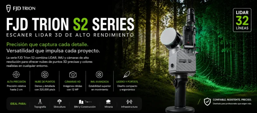
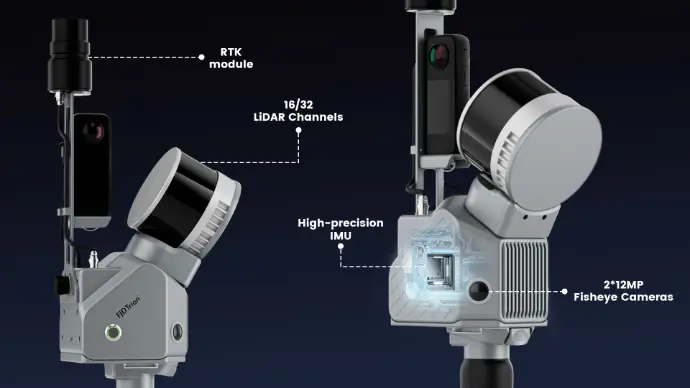
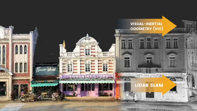
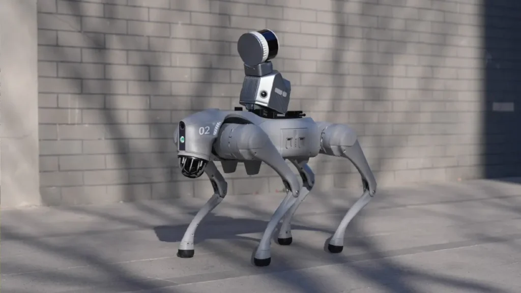
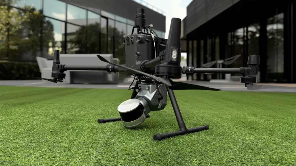
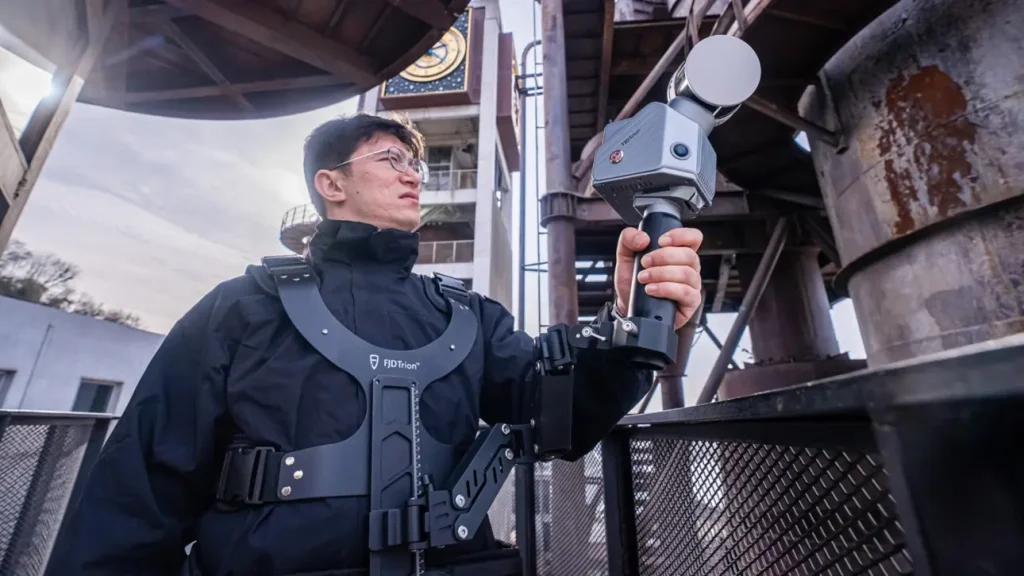
El escáner LIDAR FJD Trion S2 incorpora algoritmos avanzados VIO y SLAM para generar nubes de puntos fiables y de alta calidad. Compatible con más de 8000 sistemas de coordenadas, el S2 elimina la necesidad de largas conversiones manuales de coordenadas. Al integrarse con el software FJD Trion Scan and Model y utilizar accesorios prácticos como chaleco estabilizador, soporte para dron, soporte para coche y soporte para perro robot, el S2 optimiza la captura y el procesamiento de datos en proyectos de topografía en exteriores.
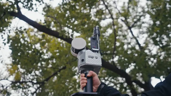
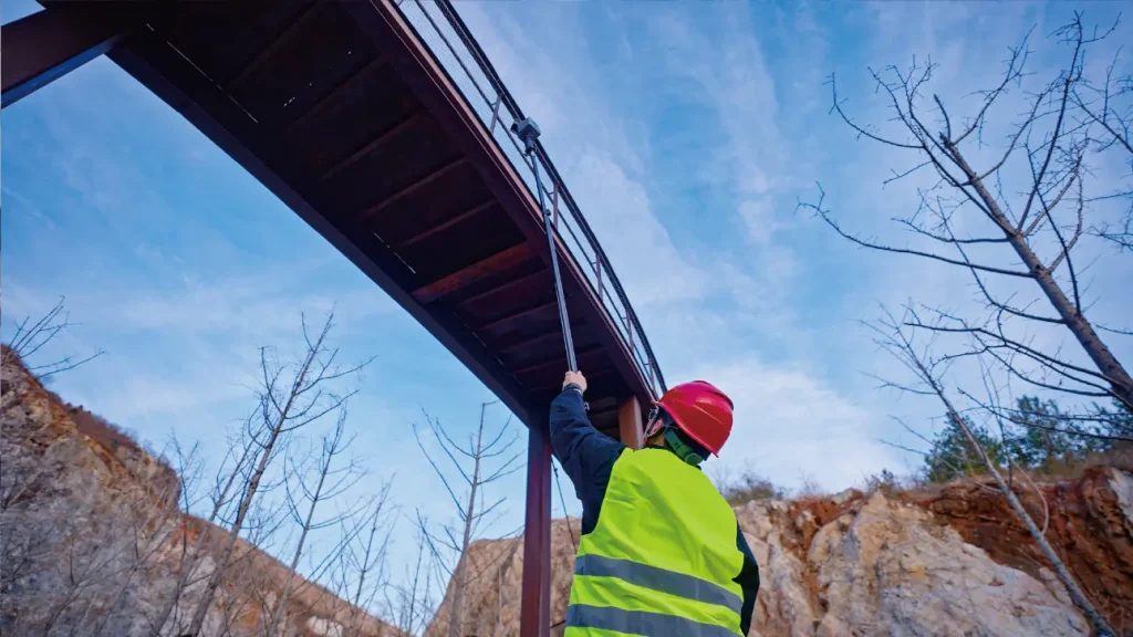
Capture nubes de puntos en todas direcciones, incluso en zonas de difícil acceso, con prácticos accesorios, como chaleco estabilizador, bastón extensible, dron, perro robot y maleta con ruedas. Puede escanear donde y cuando quiera.
Escanee con facilidad: capture, previsualice y perfeccione en tiempo real. La visualización instantánea de la nube de puntos coloreada del S2 le permite verificar la calidad y la cobertura del escaneo in situ, eliminando áreas omitidas y retrabajos antes de irse.