FJD TRION V1 RTK ROVER
[{"id":"4012","link":"https:\/\/geosearth.com\/portada\/receptor-gnss-laser-jupiter-rtk\/","name":"receptor-gnss-laser-jupiter-rtk","thumbnail":{"url":"https:\/\/geosearth.com\/wp-content\/uploads\/2026\/05\/Laser-Jupiter-RTK-GNSS.webp","alt":""},"title":"Receptor GNSS: L\u00e1ser J\u00fapiter RTK","author":{"name":"geos","link":"https:\/\/geosearth.com\/author\/geos\/"},"date":"May 26, 2026","dateGMT":"2026-05-26 20:45:56","modifiedDate":"2026-05-27 16:31:12","modifiedDateGMT":"2026-05-27 21:31:12","commentCount":"0","commentStatus":"closed","categories":{"coma":"<a href=\"https:\/\/geosearth.com\/category\/portada\/\" rel=\"category tag\">portada<\/a>, <a href=\"https:\/\/geosearth.com\/category\/productos\/\" rel=\"category tag\">productos<\/a>","space":"<a href=\"https:\/\/geosearth.com\/category\/portada\/\" rel=\"category tag\">portada<\/a> <a href=\"https:\/\/geosearth.com\/category\/productos\/\" rel=\"category tag\">productos<\/a>"},"taxonomies":{"post_tag":""},"readTime":{"min":4,"sec":15},"status":"publish","content":"L\u00e1ser J\u00fapiter RTK Caracter\u00edsticas El Jupiter Laser RTK es un receptor GNSS de alta gama que integra tecnolog\u00edas avanzadas de GNSS, IMU, l\u00e1ser y c\u00e1maras"},{"id":"4002","link":"https:\/\/geosearth.com\/portada\/sonda-acustica-portatil-hyd10\/","name":"sonda-acustica-portatil-hyd10","thumbnail":{"url":"https:\/\/geosearth.com\/wp-content\/uploads\/2026\/05\/ecosonda-portatil-hyd10.webp","alt":""},"title":"Sonda ac\u00fastica port\u00e1til HYD10","author":{"name":"geos","link":"https:\/\/geosearth.com\/author\/geos\/"},"date":"May 25, 2026","dateGMT":"2026-05-25 19:41:02","modifiedDate":"2026-05-27 15:44:19","modifiedDateGMT":"2026-05-27 20:44:19","commentCount":"0","commentStatus":"closed","categories":{"coma":"<a href=\"https:\/\/geosearth.com\/category\/portada\/\" rel=\"category tag\">portada<\/a>, <a href=\"https:\/\/geosearth.com\/category\/productos\/\" rel=\"category tag\">productos<\/a>","space":"<a href=\"https:\/\/geosearth.com\/category\/portada\/\" rel=\"category tag\">portada<\/a> <a href=\"https:\/\/geosearth.com\/category\/productos\/\" rel=\"category tag\">productos<\/a>"},"taxonomies":{"post_tag":""},"readTime":{"min":1,"sec":40},"status":"publish","content":"Caracter\u00edsticas El HYD10 es una sonda port\u00e1til de nueva generaci\u00f3n desarrollada por ComNav. Con un dise\u00f1o compacto, permite la medici\u00f3n autom\u00e1tica de la profundidad. Gracias"},{"id":"3996","link":"https:\/\/geosearth.com\/portada\/ecosonda-hyd300\/","name":"ecosonda-hyd300","thumbnail":{"url":"https:\/\/geosearth.com\/wp-content\/uploads\/2026\/05\/ECOSONDA-HYD300.webp","alt":""},"title":"Ecosonda HYD300","author":{"name":"geos","link":"https:\/\/geosearth.com\/author\/geos\/"},"date":"May 25, 2026","dateGMT":"2026-05-25 19:04:50","modifiedDate":"2026-05-25 14:07:12","modifiedDateGMT":"2026-05-25 19:07:12","commentCount":"0","commentStatus":"closed","categories":{"coma":"<a href=\"https:\/\/geosearth.com\/category\/portada\/\" rel=\"category tag\">portada<\/a>, <a href=\"https:\/\/geosearth.com\/category\/productos\/\" rel=\"category tag\">productos<\/a>","space":"<a href=\"https:\/\/geosearth.com\/category\/portada\/\" rel=\"category tag\">portada<\/a> <a href=\"https:\/\/geosearth.com\/category\/productos\/\" rel=\"category tag\">productos<\/a>"},"taxonomies":{"post_tag":""},"readTime":{"min":1,"sec":16},"status":"publish","content":"HYD300: Ecosonda ac\u00fastica profesional para levantamientos hidrogr\u00e1ficos de alta precisi\u00f3n La HYD300 es una ecosonda ac\u00fastica dise\u00f1ada para trabajos hidrogr\u00e1ficos profesionales, ideal para medir profundidades"},{"id":"3926","link":"https:\/\/geosearth.com\/productos\/escaner-laser-fjd-trion-p2\/","name":"escaner-laser-fjd-trion-p2","thumbnail":{"url":"https:\/\/geosearth.com\/wp-content\/uploads\/2026\/05\/escanerlidarp2.jpg","alt":""},"title":"Esc\u00e1ner L\u00e1ser FJD Trion P2","author":{"name":"geos","link":"https:\/\/geosearth.com\/author\/geos\/"},"date":"May 18, 2026","dateGMT":"2026-05-18 18:53:07","modifiedDate":"2026-05-26 22:46:12","modifiedDateGMT":"2026-05-27 03:46:12","commentCount":"0","commentStatus":"open","categories":{"coma":"<a href=\"https:\/\/geosearth.com\/category\/productos\/\" rel=\"category tag\">productos<\/a>","space":"<a href=\"https:\/\/geosearth.com\/category\/productos\/\" rel=\"category tag\">productos<\/a>"},"taxonomies":{"post_tag":""},"readTime":{"min":4,"sec":27},"status":"publish","content":"M\u00e1s peque\u00f1o, m\u00e1s inteligente, escanea m\u00e1s. El FJD Trion P2 marca una nueva generaci\u00f3n en tecnolog\u00eda LiDAR port\u00e1til, dise\u00f1ado para ofrecer precisi\u00f3n centim\u00e9trica, procesamiento en"},{"id":"3875","link":"https:\/\/geosearth.com\/portada\/iusv-8-vehiculo-de-superficie-autonomo-para-levantamientos-hidrograficos\/","name":"iusv-8-vehiculo-de-superficie-autonomo-para-levantamientos-hidrograficos","thumbnail":{"url":"https:\/\/geosearth.com\/wp-content\/uploads\/2026\/05\/USV-iUSV-82.jpg","alt":""},"title":"iUSV-8: Veh\u00edculo de superficie aut\u00f3nomo para levantamientos hidrogr\u00e1ficos","author":{"name":"geos","link":"https:\/\/geosearth.com\/author\/geos\/"},"date":"May 12, 2026","dateGMT":"2026-05-13 03:35:00","modifiedDate":"2026-05-25 13:33:41","modifiedDateGMT":"2026-05-25 18:33:41","commentCount":"0","commentStatus":"closed","categories":{"coma":"<a href=\"https:\/\/geosearth.com\/category\/portada\/\" rel=\"category tag\">portada<\/a>, <a href=\"https:\/\/geosearth.com\/category\/productos\/\" rel=\"category tag\">productos<\/a>","space":"<a href=\"https:\/\/geosearth.com\/category\/portada\/\" rel=\"category tag\">portada<\/a> <a href=\"https:\/\/geosearth.com\/category\/productos\/\" rel=\"category tag\">productos<\/a>"},"taxonomies":{"post_tag":"<a href='https:\/\/geosearth.com\/tag\/hidrografia\/' rel='post_tag'>Hidrograf\u00eda<\/a>"},"readTime":{"min":2,"sec":54},"status":"publish","content":"iUSV-8iUSV-8: Professional Grade & Full-Functional PlatformCOTIZAR iUSV-8El iUSV-8 es una plataforma integral para la topograf\u00eda y detecci\u00f3n hidrogr\u00e1fica. Dise\u00f1ado para misiones de topograf\u00eda profesionales complejas,"},{"id":"3789","link":"https:\/\/geosearth.com\/portada\/iso\/","name":"iso","thumbnail":{"url":"https:\/\/geosearth.com\/wp-content\/uploads\/2025\/10\/certificaciones-iso-geosearth-2025.jpg","alt":""},"title":"Nos comprometemos con los m\u00e1s altos est\u00e1ndares internacionales de calidad, sostenibilidad y \u00e9tica empresarial","author":{"name":"John Maylle","link":"https:\/\/geosearth.com\/author\/john\/"},"date":"Oct 5, 2025","dateGMT":"2025-10-05 22:28:56","modifiedDate":"2025-10-05 17:44:49","modifiedDateGMT":"2025-10-05 22:44:49","commentCount":"0","commentStatus":"open","categories":{"coma":"<a href=\"https:\/\/geosearth.com\/category\/portada\/\" rel=\"category tag\">portada<\/a>","space":"<a href=\"https:\/\/geosearth.com\/category\/portada\/\" rel=\"category tag\">portada<\/a>"},"taxonomies":{"post_tag":""},"readTime":{"min":0,"sec":0},"status":"publish","content":""},{"id":"3730","link":"https:\/\/geosearth.com\/productos\/escaner-lidar-fjd-trion-s2-series\/","name":"escaner-lidar-fjd-trion-s2-series","thumbnail":{"url":"https:\/\/geosearth.com\/wp-content\/uploads\/2025\/08\/FJD-TRION-S2-series.webp","alt":""},"title":"ESC\u00c1NER LIDAR FJD TRION S2 SERIES","author":{"name":"John Maylle","link":"https:\/\/geosearth.com\/author\/john\/"},"date":"Ago 26, 2025","dateGMT":"2025-08-27 03:31:35","modifiedDate":"2026-05-27 15:53:23","modifiedDateGMT":"2026-05-27 20:53:23","commentCount":"0","commentStatus":"closed","categories":{"coma":"<a href=\"https:\/\/geosearth.com\/category\/productos\/\" rel=\"category tag\">productos<\/a>","space":"<a href=\"https:\/\/geosearth.com\/category\/productos\/\" rel=\"category tag\">productos<\/a>"},"taxonomies":{"post_tag":""},"readTime":{"min":4,"sec":36},"status":"publish","content":"Precisi\u00f3n de 1,2 cm Colorizaci\u00f3n en tiempo real Algoritmos multi-SLAM Nube de puntos georreferenciada Adaptaci\u00f3n a m\u00faltiples escenarios Escaneo en interiores y exteriores MENOR TAMA\u00d1O,"},{"id":"3468","link":"https:\/\/geosearth.com\/productos\/tablet-gnss-t10\/","name":"tablet-gnss-t10","thumbnail":{"url":"https:\/\/geosearth.com\/wp-content\/uploads\/2024\/10\/xyztablett10.jpg","alt":""},"title":"TABLET GNSS T10","author":{"name":"John Maylle","link":"https:\/\/geosearth.com\/author\/john\/"},"date":"Oct 20, 2024","dateGMT":"2024-10-20 20:13:24","modifiedDate":"2026-05-09 21:12:07","modifiedDateGMT":"2026-05-10 02:12:07","commentCount":"0","commentStatus":"closed","categories":{"coma":"<a href=\"https:\/\/geosearth.com\/category\/productos\/\" rel=\"category tag\">productos<\/a>","space":"<a href=\"https:\/\/geosearth.com\/category\/productos\/\" rel=\"category tag\">productos<\/a>"},"taxonomies":{"post_tag":""},"readTime":{"min":1,"sec":37},"status":"publish","content":"PANTALLA HD DE 10,1\" La gran pantalla t\u00e1ctil HD de 10,1\" legible bajo la luz del sol del T10 ofrece una experiencia visual y operativa"},{"id":"3455","link":"https:\/\/geosearth.com\/productos\/tablet-gnss-t8-pro\/","name":"tablet-gnss-t8-pro","thumbnail":{"url":"https:\/\/geosearth.com\/wp-content\/uploads\/2024\/10\/T8-PRO-SINGULARXYZ.jpg","alt":""},"title":"Tablet GNSS T8 PRO","author":{"name":"John Maylle","link":"https:\/\/geosearth.com\/author\/john\/"},"date":"Oct 20, 2024","dateGMT":"2024-10-20 18:05:11","modifiedDate":"2026-05-12 22:49:57","modifiedDateGMT":"2026-05-13 03:49:57","commentCount":"0","commentStatus":"closed","categories":{"coma":"<a href=\"https:\/\/geosearth.com\/category\/productos\/\" rel=\"category tag\">productos<\/a>","space":"<a href=\"https:\/\/geosearth.com\/category\/productos\/\" rel=\"category tag\">productos<\/a>"},"taxonomies":{"post_tag":""},"readTime":{"min":1,"sec":46},"status":"publish","content":"PRECISI\u00d3N EN CENT\u00cdMETROS Integrado con un m\u00f3dulo GNSS de alta precisi\u00f3n, el T8 Pro puede rastrear simult\u00e1neamente todas las constelaciones en ejecuci\u00f3n y planificadas, proporcionando"},{"id":"3444","link":"https:\/\/geosearth.com\/productos\/receptor-gnss-y1\/","name":"receptor-gnss-y1","thumbnail":{"url":"https:\/\/geosearth.com\/wp-content\/uploads\/2024\/10\/y1-gnss-receiver-singularxyz.jpg","alt":""},"title":"RECEPTOR GNSS Y1","author":{"name":"John Maylle","link":"https:\/\/geosearth.com\/author\/john\/"},"date":"Oct 20, 2024","dateGMT":"2024-10-20 15:45:51","modifiedDate":"2026-05-09 15:43:51","modifiedDateGMT":"2026-05-09 20:43:51","commentCount":"0","commentStatus":"closed","categories":{"coma":"<a href=\"https:\/\/geosearth.com\/category\/productos\/\" rel=\"category tag\">productos<\/a>","space":"<a href=\"https:\/\/geosearth.com\/category\/productos\/\" rel=\"category tag\">productos<\/a>"},"taxonomies":{"post_tag":""},"readTime":{"min":3,"sec":20},"status":"publish","content":"CONSTELACI\u00d3N COMPLETA Con 1598 canales para el seguimiento completo de la constelaci\u00f3n, el Y1 puede ofrecer un posicionamiento confiable con precisi\u00f3n de nivel centim\u00e9trico. Gracias"}]
Características

mundial Cobertura

inclinación (V1t) 30°, 2.5cm

Segundos fijos.


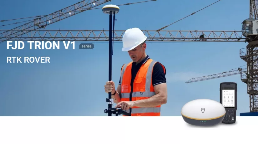
Una nueva forma de medir el mundo
La serie Trion V1 de FJD, un receptor GNSS RTK versátil y ligero, puede proporcionar rápidamente posiciones precisas en entornos difíciles con cobertura de señal global. V1t, la versión avanzada, está diseñado con una unidad de medición inercial (IMU) que le libera de mirar y nivelar la burbuja durante la medición.
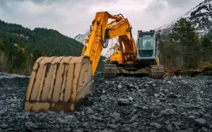
Lugar de aplicación

Marina

Construción
Maquinaria digital
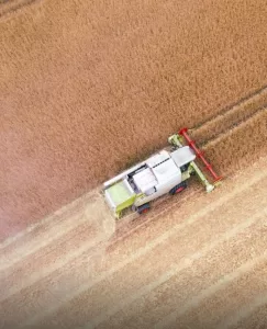
Agricultura de precisión
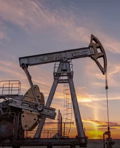
Exploración de recursos

Cerretera